Author Archives: Agent0520710

Dove Creek Area Attractions

Area visitors will find a number of outdoor attractions within 30 miles of Dove Creek, Colorado. The Snaggletooth Trail of the Dolores River Canyon and the Dolores Canyon Overlook are the premiere attractions within minutes of town.

Click on the links in the list below to bring up more information, a map, and driving directions to each location:

Snaggletooth Trail of the Dolores River Canyon (biking, rafting, hiking)
Dolores Canyon Overlook (scenic view, picnicking)
Coalbed Canyon State Wildlife Area (hunting)
Lowry Ruins National Historic Landmark and Lowry Pueblo (Anasazi cliff dwellings)
Bradfield Recreation Site and Bradfield Bridge (fishing and rafting)
Dolores River (Lone Dome) State Wildlife Area (fishing, hunting, picnicking)
Mcphee Dam (below the dam)

Click on symbols in the map below for additional information such as distance from the Country Inn Motel in Dove Creek, Colorado.


View Dove Creek Area Attractions in a larger map

Disclaimer: These maps and related information are provided for your convenience. Though we endeavor to provide good information, Country Inn Motel or any related parties are not liable for inaccuracies, damages, or injuries from the use of this information.

Snaggletooth Trail of the Dolores River Canyon

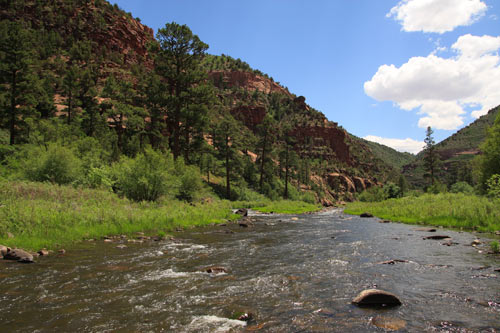
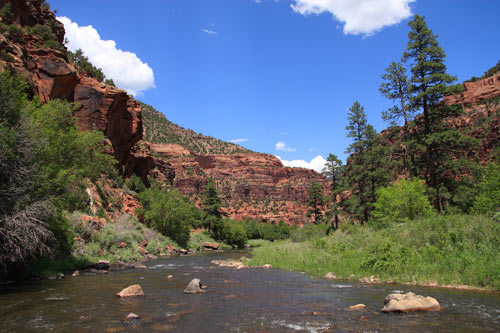
Surrounded by the red sandstone walls of the scenic Dolores River Canyon, bikers, hikers, rafters, fishing enthusiasts, and picnickers will enjoy the Snaggletooth Trail, located approximately 7 miles from the Country Inn Motel in Dove Creek, CO. A recreation site is located at the beginning of the trail near the Dove Creek pump station and offers a small picnic area with parking and a boat ramp. Even when the river is low, a few deeper pools can usually be found by heading downstream. Visitors will find at least a few good points to park or turn around further down the trail. Although vehicle traffic is usually very light on the trail, be aware that many stretches are a single lane wide.

The map below shows the route to the canyon and the start of the Snaggletooth Trail. Click on map symbols and the blue route for more specific driving directions. Vehicles with low clearance may have difficulty in some places on the rocky road down to the canyon.


View Driving directions to Snaggletooth Trail in the Dolores River Canyon in a larger map

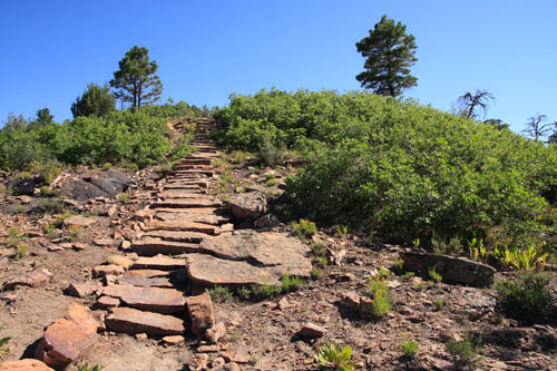
Biking and Hiking: The entire trail is approximately 20 miles before connecting back to county roads that lead to Hwy 141 near Slick Rock, CO. The first 10-11 miles of the Snaggletooth Trail are considered easy to intermediate for mountain biking (yellow trail on the map below). Turn around at the gooseneck in view of Pyramid Rock to avoid a difficult/advanced bicycling trail for the next 10-mile section. The advanced stage of the trail starts with a section just over 4 miles long (orange trail on the map below). This phase of the Snaggletooth trail is bound to be rockier, more difficult to travel, and less-maintained. After approximately 4 miles, you must wade (ford) across the river to continue the trail on the other bank.

The river may be too deep and swift to safely cross during certain times of the year (spring especially). Caution: warnings suggest that crossing when river flow is at 100 c.f.s. or greater is dangerous, and 200 c.f.s. or greater should not be attempted. Flow rates can be seen at http://doloreswater.com/releases.htm or call 970-882-2164 for current conditions.

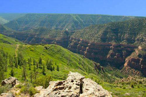
Once across the Dolores River, the last phase of the advanced trail (red trail on the map below) winds approximately 5.5 miles and includes areas with steep climbs out of the canyon, eventually connecting with 16R Road. Caution: sections of the trail may stray close to cliff edges and steep drops. 16R Road starts east and then mostly north for approximately 1.3 miles before connecting with 13R Road. Stay left at the fork in the road to take 13R Road for approximately 3.2 miles to Hwy 141. Slick Rock, CO, will be approximately 5 miles west on Hwy 141.

Click on colored routes or landmark symbols on the map below for additional information.


View Snaggletooth Trail near Dove Creek in a larger map

Fishing: Because this part of the river is well downstream of the Bradfield Bridge, fish can be kept when caught. Between Bradfield Bridge and McPhee Dam, several miles upstream, fishing is catch-and-release only.

Rafting: When water flow is high enough, rafting can take visitors miles down the Dolores River. The height of rafting season through this stretch usually occurs during the month of May. Downstream of the Dove Creek pump station, class III rapids become more common than upstream toward the Bradfield Bridge. In the vicinity of seven miles downstream of the pump station, rafters should encounter Little Snag, a rapid warning of the upcoming fierce Snaggletooth rapid. Snaggletooth, a class IV-V rapid, comes up in the next mile or so beyond Little Snag. Portage trails along this stretch should allow alert and/or concerned rafters to either scout ahead or bypass Snaggletooth entirely.

Disclaimer: These maps and related information are provided for your convenience. Though we endeavor to provide good information, Country Inn Motel or any related parties are not liable for inaccuracies, damages, or injuries from the use of this information.

Dolores Canyon Overlook

The Dolores Canyon Overlook is approximately an 11-mile drive east of Dove Creek on mostly gravel roads that even low-clearance vehicles should be able to navigate reasonably well. From the parking area, the overlook is still a short hike through picnic sites and down a fairly obvious trail to a viewing area with short stone walls. The view varies from sandstone cliffs, to scenic green landscapes, to areas of the Dolores River far, far below. The outer edges of the picnic area are surrounded by steep cliffs and potentially dangerous drops in some places without fences or obvious warnings, so scout the perimeter before setting very young children loose.

The map below shows the route to the Overlook. Click on map symbols for more information. Click on the blue route for more specific driving directions.


View Driving directions to Dolores Canyon Overlook near Dove Creek, CO in a larger map

Coalbed Canyon State Wildlife Area

Coalbed Canyon State Wildlife Area is about 7 miles west of Dove Creek near the Utah state line. Providing areas for hunting and wildlife viewing, the terrain is a mixture of desert, desert canyon, pinyon-juniper woodlands, and sage brush. The wildlife area is divided into four sections, of which the three largest are shown on the map. The easiest to find is right off of Hwy 491 by turning south on County Road 2. The second section begins further south on County Road 2 and the intersection of County Road H. The third section is adjacent to the state line on the north side of Hwy 491. The fourth section, not marked on the map, is a bit north of the highway and east of County Road 2.


View Driving directions to Coalbed Canyon State Wildlife Area in a larger map

Lowry Ruins National Historic Landmark and Lowry Pueblo

Approximately 24 miles from Dove Creek and a bit west of Pleasant View, Colorado, Lowry Ruins National HIstoric Landmark contains 1000-year-old Anasazi ruins in an area called the Canyons of the Ancients National Monument. Part of the Landmark, Lowry Pueblo has 40 ancient rooms and a number of circular chambers called kivas. Open only during daylight hours, the site has a picnic area and restrooms.

The map below shows driving directions from the Country Inn Motel in Dove Creek, Colorado. The turn onto County Road CC is in the tiny settlement of Pleasant View, about 15 miles from Dove Creek.


View Driving directions to Lowry Ruins National Historical Landmark, Pleasant View, CO in a larger map

Having earned its name, Canyons of the Ancients National Monument has more than 6000 ancient Native American sites, but much of it is said to be on difficult, unpaved roads and trails. For those with more rugged vehicles, there is certainly more to explore. Private lands intersect the area, but you can obtain a map marking authorized routes from the Anasazi Heritage Center near Dolores, Colorado.

Bradfield Bridge Recreation Site and Bradfield Bridge

Located east of Cahone, Colorado, Bradfield Bridge Recreation Site and Bradfield Bridge are good areas for fishing and rafting. The recreation area is just downstream of the bridge and has picnic areas and a boat ramp into the Dolores River. Rafters can float 19 miles ahead into the Dolores River Canyon just past the Dove Creek pump station to Mountain Sheep Point Recreation Site (the starting point of the Snaggletooth Trail), where the next boat ramp awaits. Rafters can end their journey there or continue onward toward Slick Rock, Colorado, where bigger rapids such as Snaggletooth (Class IV-V) await.

Fish may be kept downstream of he Bradfield Bridge. Fish caught between the bridge and McPhee Dam are catch-and-release only.

The map below shows the route to the recreation site. Click on map symbols for more information. Click on the blue route for more specific driving directions.


View Driving directions to Bradfield Recreation Site, Cahone, CO in a larger map

Dolores River (Lone Dome) State Recreation Area

The Dolores River/Lone Dome State Wildlife Area east of Cahone, Colorado, provides fishing, hunting, wildlife viewing, and picnic areas along the Dolores River. The route will eventually lead to the area directly below McPhee Dam for those who continue eastward. Any fishing done between Bradfield Bridge and the dam is catch-and-release only. Fish may be kept downstream of Bradfield Bridge.

The map below shows the route to the recreation area. Click on map symbols for more information. Click on the blue route for more specific driving directions.


View Driving directions to Dolores River (Lone Dome) State Wildlife Area, Pleasant View, CO in a larger map

McPhee Dam

Seeing McPhee Dam from below McPhee Reservoir may be an interesting view for some. The route to the dam passes through the Dolores River/Lone Dome State Wildlife Area east of Cahone, Colorado. Visitors will find places to fish and picnic along the way. Any fishing done between Bradfield Bridge and the dam is catch-and-release only. Fish may be kept downstream of Bradfield Bridge.

The map below shows the route to the dam. Click on map symbols for more information. Click on the blue route for more specific driving directions.


View Driving directions to McPhee Dam (below dam) in a larger map